 Explore
Canggu
Explore
Canggu
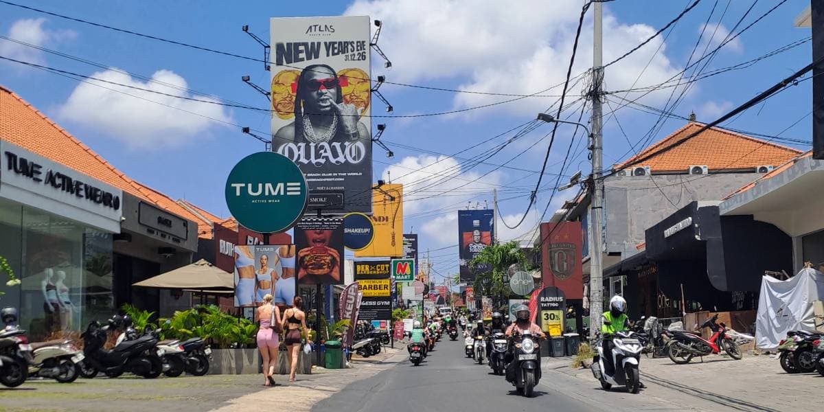
When people in Canggu talk about "the Shortcut," they're almost always referring to one specific, notorious backroad: the narrow passage cutting between Berawa and Batu Bolong. It isn't an officially engineered municipal thoroughfare, but an informal connection that evolved into an indispensable artery of Canggu's daily mobility.
Over the years, the Shortcut has achieved legendary status among locals, digital nomads, and holidaymakers. It has inspired viral social media reels of cars slipping into drainage ditches, countless travel memes, and daily debates at sunset beach clubs. Here is the realistic, on-the-ground guide to understanding the Canggu Shortcut in 2026, its history, rules, and how to navigate it safely without adding to the chaos.
Quick Summary: The Canggu Shortcut at a Glance
The Canggu Shortcut is a narrow, informal road running between Jl. Subak Canggu and Jl. Anggrek, linking the Berawa area directly to Batu Bolong. It started decades ago as a farmer's footpath through rice fields and was gradually paved as traffic pressure grew. While recent upgrades have widened parts of it and added sidewalks, cars can only enter from the west end and cannot pass each other. Taking a scooter is by far the safest and fastest option; driving a four-wheeled car is strictly not recommended.
Table of Contents
- What Is the Canggu Shortcut?
- From Farmer's Path to Built-Up Backroad: A Short History
- The Route: Where It Starts and Ends
- Why It's a Vital Connector Between Batu Bolong and Berawa
- Why It's So Narrow & The One-Way Rule for Cars
- Car vs. Scooter: Which Should You Use?
- Practical Tips for Riding the Shortcut Safely
1. What Is the Canggu Shortcut?
The Canggu Shortcut is a narrow backroad that cuts through agricultural land between Berawa and central Batu Bolong. It was never mapped or designed as a conventional public highway. Instead, it originated as a modest rural farmer's path (*jalan subak*) used by local villagers to walk to their agricultural plots or ride bicycles between banjars.
As Canggu underwent explosive tourism expansion over the past decade, the main arterial roads quickly locked into permanent gridlock. Motorcyclists and adventurous drivers began using this unpaved farmland path as an escape valve to avoid the slow crawl through Kerobokan and Raya Canggu. Over time, sections were concreted, paved, and patched together into the route drivers use today.
Because it technically sits on private and subak agricultural land rather than a dedicated municipal road reserve, standard infrastructure elements—such as lane markings, generous safety shoulders, traffic lights, and street lamps—have historically been missing, giving it a raw and unpredictable character.
2. From Farmer's Path to Built-Up Backroad: A Short History
For many years, the defining image of the Shortcut was a rustic, single-lane strip of asphalt flanked on both sides by lush green rice terraces. In those early years, the road had no safety barriers, no elevated pedestrian sidewalks, and often no distinct verge separating the road surface from the muddy irrigation paddies below.
Under those conditions, it became infamous for tourist mishaps. Unseasoned scooter riders taking selfies, as well as oversized private hire cars misjudging the road's perimeter, routinely slipped off the edge and ended up half-submerged in the rice paddies. Videos of bewildered drivers standing next to tilted vehicles spawned whole social media pages dedicated to Shortcut blunders.
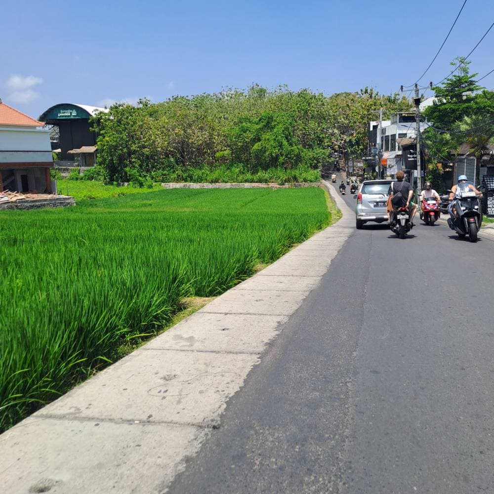
In recent years, the local government and banjar communities undertook practical upgrades. Parts of the road were widened, resurfaced with proper asphalt, and reinforced with a raised pedestrian sidewalk. These improvements significantly cut down on vehicles tumbling into ditches.
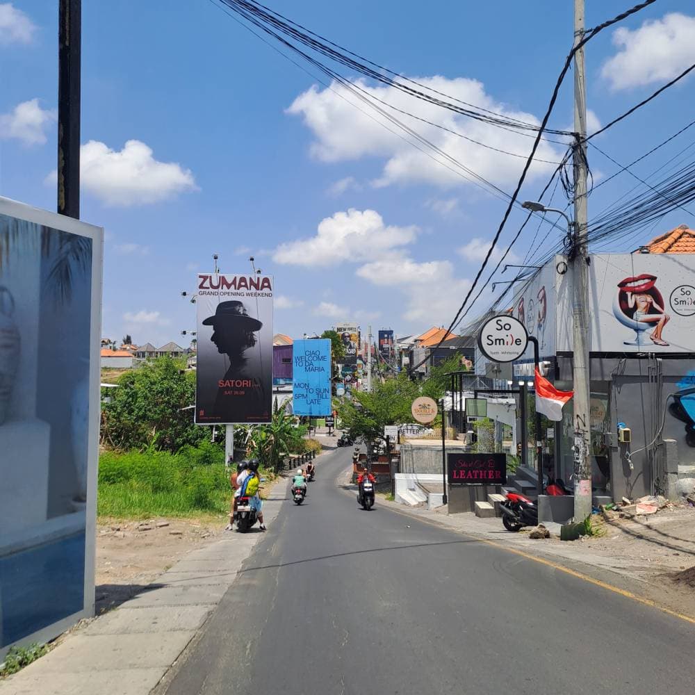
However, the rustic visual appeal has also dramatically shifted. Because the Shortcut funnels thousands of people daily between Canggu's two hottest hubs, commercial developers quickly leased land alongside it. Today, large billboards, trendy boutique cafes, smoothie bars, clothing stores, and mini-marts line much of the road, leaving only small fragmented patches of open rice fields. It now functions much more like an active, narrow commercial lane than a secluded countryside path.
The Visual Shift: Canggu Shortcut in 2021 vs. 2026
Nothing illustrates Canggu's dizzying speed of development quite like looking at the exact same stretch of the Shortcut half a decade apart. What was once an unassuming rural strip has morphed into a dense, high-traffic commercial corridor.
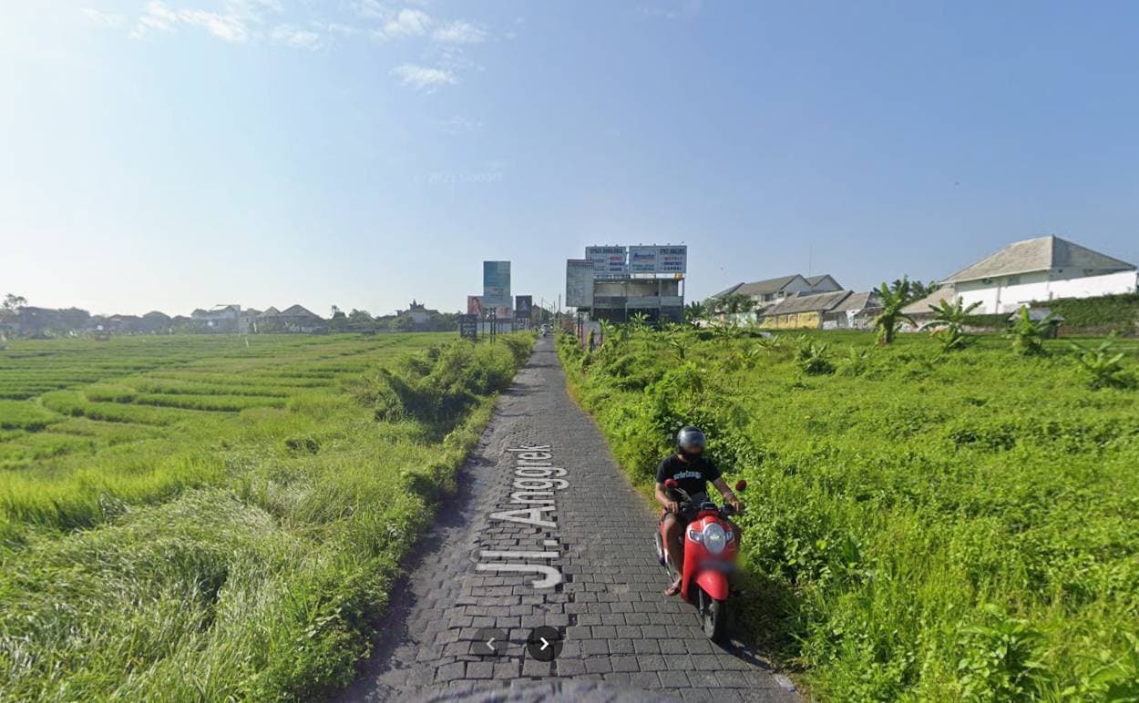
Back in 2021, the Canggu Shortcut retained much of its rustic Balinese farming soul. As seen in the photo above, the path was flanked by vast, unobstructed green rice terraces stretching towards the horizon. There were practically no commercial storefronts, no neon signs, and certainly no concrete sidewalks. The paved and paved-stone surface was barely wide enough for two motorbikes to pass each other comfortably, and any rider who veered off by even a few inches risked plunging straight into the muddy irrigation ditches—giving birth to the viral Internet memes of tourist scooters stuck in the mud.
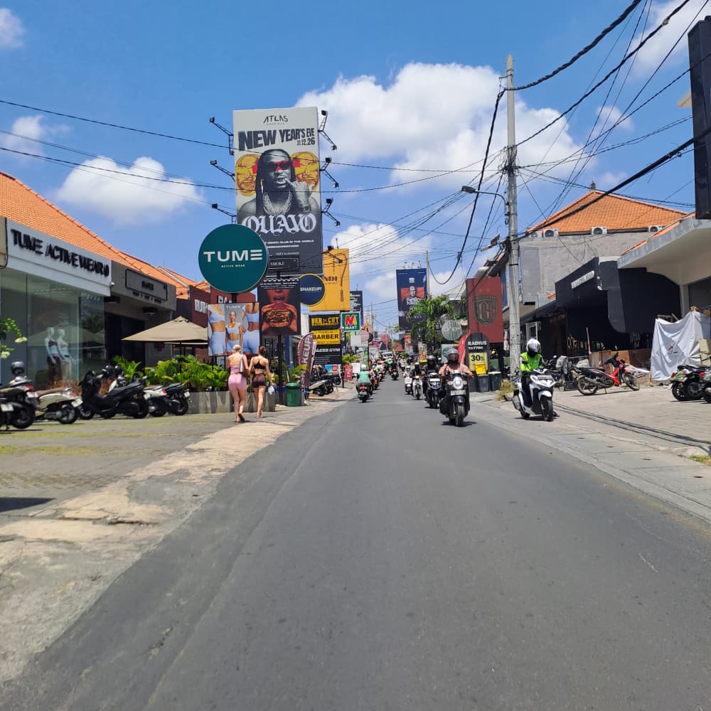
Fast forward to 2026, and the transformation is staggering. The quiet agrarian scenery has been replaced by rapid, massive commercial construction:
- Erosion of Agricultural Greenery: The endless rice fields shown in the 2021 photo have almost completely vanished along the road frontage, subdivided and leased out for prime retail and hospitality spaces.
- Booming Commercial Infrastructure: Trendy activewear boutiques, specialty cafes, aesthetic restaurants, tattoo studios, and multi-storey retail establishments now directly hug both sides of the roadway.
- Towering Billboards & Modern Signage: Giant advertising billboards, digital promos, and brand banners now dominate the skyline above the road, competing for the attention of the thousands of commuters passing through every hour.
- Structural Upgrades & Sidewalks: To cope with extreme daily traffic and prevent accidents, municipal and banjar teams widened critical sections, laid continuous smooth asphalt, and constructed raised concrete sidewalks where muddy ditches once lay.
While these upgrades make traversing the Shortcut safer and more practical for daily commuters, they also symbolize Canggu's undeniable shift from a serene surfing and farming sanctuary into one of the world's most bustling lifestyle epicenters.
3. The Route: Where It Starts and Ends
Geographically, the original Canggu Shortcut runs between Jl. Subak Canggu on the western end (approaching Batu Bolong) and Jl. Anggrek on the eastern end (leading into Berawa).
When riding from end to end without traffic hold-ups, traversing the Shortcut on a scooter takes roughly 10 to 15 minutes. However, if a four-wheeled vehicle ignores warnings or gets jammed at a pinch point, travel time can double or triple in an instant.
4. Why It's a Vital Connector Between Batu Bolong and Berawa
Despite its tight corners and frequent congestion, why do thousands of people continue to use the Shortcut daily? The answer comes down to pure geographic reality.
As the crow flies, Batu Bolong and Berawa are right next to each other, separated only by a narrow river valley and remaining agricultural land. However, the formal municipal road system forces vehicles to detour northward via Jl. Raya Canggu and Kerobokan—a sweeping, congested detour that easily takes 45 to 60 minutes during peak hours (see our complete guide to Canggu traffic peak hours and bottlenecks).
The Shortcut bridges this gap directly. For expats commuting between their villa in Berawa and their favorite coworking space or gym in Batu Bolong, cutting through this backroad is the only way to make daily life in Canggu practical without spending half the day sitting in traffic.
5. Why It's So Narrow & The One-Way Rule for Cars
At several critical pinch points along the route, the road width narrows to barely three meters. While two scooters can easily pass each other with room to spare, two standard cars cannot pass each other simultaneously.
To avoid perpetual head-on standoffs, local authorities and banjars instituted an essential traffic rule:
- Cars may ONLY enter from the west end (Jl. Subak Canggu toward Jl. Anggrek). Four-wheeled vehicles driving from east to west are strictly barred.
- Motorbikes and scooters enjoy two-way access in both directions.
Unfortunately, visiting tourists driving rental cars or outside taxi drivers who blindly follow GPS prompts occasionally enter from the wrong direction. When this happens, traffic in both directions grinds to an absolute halt. The offending driver is forced to reverse hundreds of meters along an uneven lane with dozens of irritated scooter riders waiting behind them.
6. Car vs. Scooter: Which Should You Use?
| Criteria | Scooter / Motorbike (Recommended) | Car / Four-Wheeler (Not Recommended) |
|---|---|---|
| Ease of Navigation | Very easy; plenty of clearance to pass oncoming scooters and filter smoothly. | Extremely stressful; tight clearances with concrete walls and sidewalks. |
| Travel Time | 10–15 minutes on average, even during busy periods. | 25–45+ minutes; vulnerable to complete blockages if any vehicle stalls. |
| Directional Freedom | Allowed in both directions (West to East & East to West). | West-to-East entry ONLY; prohibited from entering via Berawa (Jl. Anggrek). |
| Damage Risk | Low (if riding cautiously and sober). | High risk of scraped mirrors, scratched bodywork, and wheel rims. |
| Final Verdict | The primary choice: perfect fit for Canggu's infrastructure. | Avoid entirely: take the main road bypass via Kerobokan instead (check our Canggu traffic survival guide for alternative routes). |
7. Practical Tips for Riding the Shortcut Safely
If you choose to ride a scooter through the Shortcut, keep these essential safety practices in mind:
- Keep your speed down: The Shortcut is not an open drag strip. Blind corners around compound walls and sudden pedestrian crossings mean you must ride defensively at 20–30 km/h.
- Be polite and yield at pinch points: When oncoming scooters approach a narrow section, slow down, move toward your side, and allow each other to pass smoothly without clipping handlebars.
- Avoid the Shortcut during torrential downpours: While paving has eliminated the old mud traps, heavy tropical storms can submerge low sections and reduce traction dramatically. Lighting at night is also sparse.
- Never attempt the Shortcut while intoxicated: Many serious accidents in Canggu happen late at night when riders leaving beach clubs try to navigate tight corners after drinking. Order a Gojek/Grab bike or hail a reputable driver instead.
- Check your scooter basics: Ensure you rent a reliable, well-maintained scooter from a reputable shop, wear a properly fastened helmet at all times, and carry your International Driving Permit for Bali to stay legally compliant.
Frequently Asked Questions (FAQ)
Where does the Canggu Shortcut start and end?
Can I drive a car through the Canggu Shortcut?
How long does it take to drive the Canggu Shortcut?
Why do people still use the Shortcut if it is so narrow?
Do vehicles still fall into the rice fields on the Shortcut?
Is the Canggu Shortcut an official government-built highway?
Is the Canggu Shortcut still surrounded by scenic rice fields?
This guide is periodically reviewed and updated by Fares, Editor at Explore Canggu, based on ground research in Canggu since 2022. Local traffic rules, one-way directional signage, and road conditions are subject to changes by local banjar authorities.
Exploring Canggu by Scooter?
Rent from verified local providers with transparent pricing, comprehensive insurance, and helmets included.
View Trusted Scooter RentalsRelated Canggu Guides & Resources
Expand your transport knowledge with these practical Canggu guides:
- Canggu Traffic 2026: Peak Hours, Shortcuts & How to Survive – The complete picture on Canggu's traffic bottlenecks and road projects.
- Best Scooter Rentals in Canggu – Daily and monthly rental options reviewed.
- Bali Police Checkpoints & Scooter Fines Guide – What to carry and expect at traffic checkpoints.
- Grab & Gojek Red Zone Rules in Canggu – Where ride-hailing apps can and cannot pick up or drop off.
- Where to Stay in Canggu (2026) – Comparing Batu Bolong, Berawa, and Pererenan.